The ninth of a series of jaunts in the key of white. This week: the second half of a walk on Omand’s Creek from the Assiniboine River to Brookside Cemetery.
Passing through the concrete conduit beneath the Sargent Street bridge marks something of a transition point for the frozen Omand’s Creek. Behind me, the landscape has been commercial with big box stores, parking lots, hotels and busy roads lining the straight-jacket course of the creek as it makes its way south to the Assiniboine River. Ahead is all industrial. And my passage upstream this warmish winter afternoon all the more challenging.
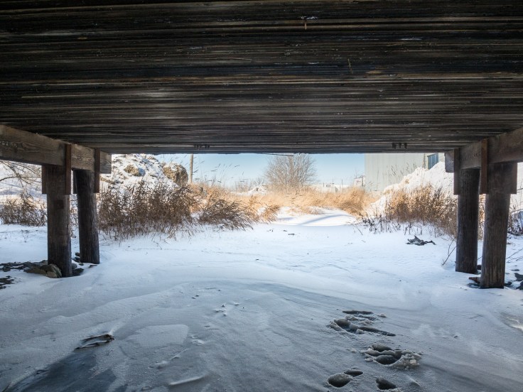
It starts with a (thankfully) rare instance of the creek being paved over. Suspended above me is a parking lot, a vast concrete ceiling propped up on a grid of spindly concrete posts and beams. Down here, it is a sinister crawl space, Omand’s Creek relegated to inconvenience. To think that this might have been the creek’s fate elsewhere had brighter minds not intervened with the establishment of Bluestem Nature Park.
The ice down here does not look safe and, for the first time, I must temporarily leave the creek and climb up to Empress Street. From this perspective the parking structure looks to be no more than another lot fronting an insipid strip of industrial development. So much wasted human effort for such an ugly, ill-advised addition to the cityscape. So much contempt for the scraps of nature below.
Past the parking lot, I return to the creek. I am definitely on my own now. There are no human tracks. Last year’s reeds, stiff and golden brown, clog my path. The snow is deep and wet. Moving forward is a sweaty challenge.
I pass alongside a large grassy hill rising high above the city’s flat landscape. This is Westview Park, a small refuge from my industrial surroundings. From its glorified peak are panoramic views in all directions. But the park itself has a decidedly industrial heritage. More commonly known as Garbage Hill, it is just that, a landfill that operated from 1875 to 1948 before becoming a park in 1960.
Past here, the surrounds are more overtly industrial: a drywall factory on one side and a grocery distribution centre on the other. The industrial sheds of a steel fabricator appear just before I pass under Saskatchewan Avenue and the heavy timbers of a rail spur line. The creek suddenly bends to the west and just as suddenly bends once more to return to its due north path.
There is a mechanical precision to the course of Omand’s Creek, one drawn on a drafting table in an engineer’s office rather than prescribed by the vagaries of nature. An early map, Plan of the Settlement on Red River, as it was in June 1816, shows a scraggly Catfish Creek, as it was then called, winding its way in a southeasterly direction to the Assiniboine River (or the Ossiniboyne River or Western Branch of the Red River, according to the map). Catfish Creek was later renamed Omand’s Creek, after John Omand (1823-1905), who lived near its mouth. By 1946, City maps show a much different path for Omand’s Creek. Other than having the same meeting point at the Assiniboine River, the course of Catfish Creek in 1816 is completely different from that of Omand’s Creek in 1946. Since 1946, the creek’s route has been modified even further, being aligned ever more closely to the grid of streets closing in around it.
I’m heading north on that most recent realignment. The creek is broader, a flat expanse of clean, white, deep snow. The heavy industries hang back from the gently sloped banks, giving it—and me—room to breathe. A parkland, so-to-speak, surrounded by super-scaled tin sheds, rusting machines and gantry cranes. Then the creek turns left and due west. The trail is getting tough now. The snow is deep. I can feel my thighs ache with every laboured step. In places, the bullrushes are thick, forcing me to battle my way through or give up and climb the steep bank to circumnavigate a particularly impenetrable patch. A number of bridges cross overhead. Most tunnels I can navigate, hunched over. A few are just too low. I must climb up and over.
I pass through one more steel conduit under some road I can’t identify and emerge at the edge of the James Armstrong Richardson International Airport. Or, more correctly, at the edge of a vast swath of prairie that it claims as its own.
Omand’s Creek continues through the airport property and I really want to follow it. But there are these tall chain link fences, not blocking my path but guarding the creek’s flanks and bearing an ominous warning: NO TRESPASSING, by order MINISTER OF TRANSPORT. It is a message repeated in French, thereby suggesting that this is more than some local-yokel quasi-official warning I might otherwise be tempted to ignore. No, a threatening message in both French and English, from a minister of Canada’s government, is not to be ignored.
So I reluctantly scale the bank to the road above. From here it looks like the creek will take another engineered right hand turn just up ahead, so I skirt along its edge, following the ominous chain link fence and its frequent warnings. I can can just make out the airport terminal through the steel grey links, a hazy form well off on the distant horizon. On my side of the fence is Sherwin Park, another industrial complex consisting of ample pavement and a long row of regimented storefronts all dressed in orange brick. With mirrored glass. And decorative trim. A valiant attempt by some developer to humanize the dull sheds underneath.
At the end of Sherman Park, I meet up with the creek once more as it swings north. A short walk takes me under Notre Dame Avenue. Finally, a true park reveals itself. The Red River Community College Campus lies far off to the right with an expansive snow-covered plain lying between me and it. On the left is Brookside Cemetery, one of Winnipeg’s finest and oldest. I follow the creek along the edge of the cemetery. The snow is deep, wet and heavy. My boots can’t keep up and I feel a cold dampness through my socks and between by toes. The dead reeds are dense and I need to push hard to smash my way through. I am so close to my destination at the far end of the cemetery. But it is hard slogging.
The end comes in the cemetery’s Field of Honour. I stand exhausted but humbled amidst the markers of over 10,000 service men, women and families interred here since 1915. The uniform rows of grey stone markers rise starkly, silently from the pure white snow. They stretch on and on under outstretched limbs of bare trees.
Just as my journey began in a sylvan setting, so it ends in a similar yet so much more wrenching place. My trek upstream on frozen water, through lands that have declared open war on this water course, has been challenging. It is not a pretty walk. It is not defined by beauty, although beauty is still here to be discovered. No, this is more of a pilgrimage. This voyage up a simple creek tests our respect for the world we occupy and then concludes in a place of infinite respect.
It’s late February. Winter is breathing its last cold breath. Soon there will be no water-top path to follow. Water will flow through the cemetery, beneath its leafy canopy, through the steel and concrete conduits, along its straightened path and on to the Assiniboine River. New bullrushes will spring from the creek bed. Redwing blackbirds will chirp. Frogs will croak. And the creek will continue its private life, hidden below the bustle of cars and trucks, lost below the alien world of commerce and industry.


I also love exploring the oft-ignored corners of our city. What a pleasure it is to have found your site! Be well!
Thanks Christian! Happy walking.